This is photo essay on my experience in the Wind River Range in Wyoming in mid-August 2007.
Most Continental Divide Trail (CDT) thru-hikers hike the CDT along the Wind River Range, which is spectacular. However, I wanted something more. I wanted to hike the actual Continental Divide in the Wind River Range. That means getting high above the trail, traversing glaciers and rocky terrain where there is no trail at all. Few have traversed the entire Wind River Range along the divide, especially without resupply. I'm glad I did it because it was the most beautiful section of the entire CDT.

South of Union Pass, the Divide got interesting. A snow storm blew through and early the next morning I could see what was left over.

I always opted for the highest route whenever possible.

The fresh snow started melting away by noon.

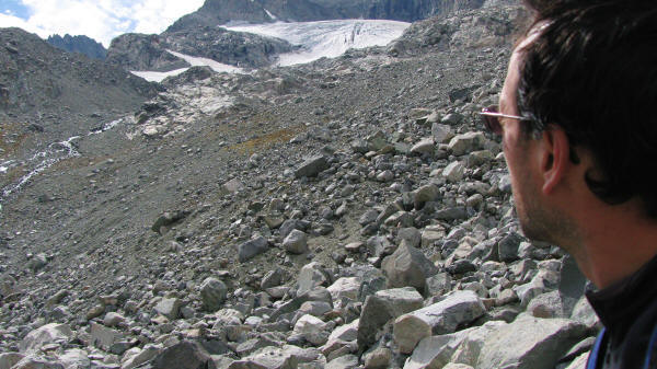
There is no trail. Fields of rocks make walking tricky. You wouldn't want to twist an ankle up here when you're all alone.

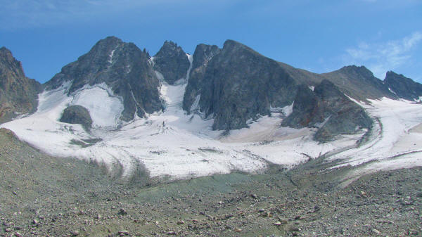
Above 10,000 feet, glaciers and crevasses start to appear often. This is the Continental Glacier, which lies right on top of the Divide.

The weather is temperamental on the Divide. Being above the tree line, you're exposed all the time. Try to avoid lightning storms if you can when you're in this section. Easier said than done!

I woke up early everyday to make as much progress as possible. At night, I hoped to find a semi-sheltered spot to setup my tarp. This was tricky because I didn't have trekking poles.

Without trekking poles, I used rocks to hold down my tarp. I didn't expect rain that night, but the tarp trapped a bit of heat. The rocks around me sheltered me from the cold wind.

The mornings were freezing, so I wore my Jacks R Better convertible sleeping bag.

Another picture of the magical place I found. I went up the glacier that you see in this picture without an ice axe or crampons. Higher up there were crevasses everywhere.

Pretty to see the ice breaking up.

My tiny G5 Gossamer Gear backpack was all I had.
 via Tourist Creek. The reason they do this is to avoid the glacier filled terrain south of Tourist Creek. I didn't want to avoid it because I knew it would be the most scenic portion. The photos that follow should inspire you to go for it and not wimp out by taking Tourist Creek.")
The few CDT thru-hikers who venture onto the divide usually get onto it (or get off of it) via Tourist Creek. The reason they do this is to avoid the glacier filled terrain south of Tourist Creek. I didn't want to avoid it because I knew it would be the most scenic portion. The photos that follow should inspire you to go for it and not wimp out by taking Tourist Creek.

I got up high to avoid some crevasses but eventually I had to go down and confront them. I jumped over a dozen crevasses, hoping that I didn't slip and fall into one of them.

With no one to belay me, hoping crevasses is risky business! Don't do this trek if you're not an experienced mountaineer and you're a bit crazy.

Glacier water mixes with the minerals to create lakes of an aqua blue color that is hypnotic!

I enjoyed climbing up this slippery glacier.
. They had ice axes and crampons. Lots of gear. They wondered what I was doing there with only six pounds of gear including an umbrella as my")
These five guys were Outward Bound instructors on a 2 week vacation. They were also doing the traverse, but they had three resupply spots (pack animals were bringing in the food). They had ice axes and crampons. Lots of gear. They wondered what I was doing there with only six pounds of gear including an umbrella as my "ice axe."

Glacier melt off was cool to watch and walk over. The water tastes great!

It's hard to capture just how small you feel here.

I cross through this field, straight over that mini pass straight ahead.
If the earth warms up, these glaciers won't return until the next glacial period, which, if it were to occur would kill off far more humans than global warming.
The climax of my traverse was near Gannett Peak, the tallest mountain in Wyoming at 13,804 feet (see picture below). My plan was to summit it. However, I arrived there at 4 p.m., I was running low on food, and I still had 100 miles to go. If I went up this mountain, I would be coming down in the darkness and I would be camping where this picture was taken, around 12,500 feet.

If you look closely, you can see the route I would have had to take. I would go up the right side of the glacier, traverse on top of it, then go up a snow covered chute on the left side that is hard to see because it is in shadows. Then I would gain the top ridge and traverse up and to the right to the summit on top of slick ice. After tagging the summit (around 7 p.m.) I would have to hurry down the same way, just when the temps start dropping fast (after sunset) and the ice begins to harden and get very slippery. If I slipped here (which is easy when you don't have an ice axe or crampons), it would be a long fall. If I broke a leg/ankle, I had little food on me to sustain me while I hoped that help would arrive.
Even if I bagged Gannett Peak, I would have spent a lot of valuable energy just to do it. Doing those last 100 miles with only 6,000 calories left in my backpack would be leave me starving by the last day or two. After thinking all this over, I took one one last look at the mountain, turned my back on it, and walked over Bonney Pass, descended into the Titcomb Basin, and finally rejoined the CDT, which led me to South Pass City for a resupply. I was starving because I was surviving on chocolate bars. Avoiding Gannett Peak was probably the only time I really restrained my desires on the CDT. I always tried to rise to any challenge. This time, I wimped out.
If you're planning to thru-hike the CDT. Don't take the easy way through the Wind River Range. Challenge yourself and see the most spectacular, rewarding section on the entire Divide. Don't go up and down Tourist Creek, do the whole Divide! If you have zero mountaineering skills, then go with someone who does. Good luck and tell me how it goes!